|
|
||

|
||
|
|
||
PI Digital Earth Goes to WESTGIS Conference with JPLSeptember
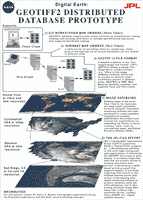
11, 2000 Position Integrity's "Digital Earth" application will be highlighted as the display engine behind NASA/JPL's new satellite-based imagery datasets at WESTGIS in Sacramento from September 10-13, 2000. The combined suite is being demonstrated at this conference for the benefit of geospatial experts from the civilian, scientific and military GIS communities and the technology showcase includes the GeoTIFF 2 Distributed Database Prototype. Based on the Web Mapping Testbed (WMT) specifications for open and interoperable data dissemination, a Position Integrity "thick client" running on a Silicon Graphics / Windows NT workstation will let conference users roam, pan and zoom a variety of JPL generated maps, imagery and colorized shaded relief depictions.
In addition a "thin client" using Netscape's web browser running on a portable Macintosh will show Internet connectivity to the same data being presented to users by a Position Integrity web server in Irvine, CA.
An informative poster board describing the demonstration and GeoTIFF architecture is available for view and download by clicking on the links below.
Browser View (~83 KB) | Download View (~ 2 MB zipped)
For more
information contact Robert A. Severino at Position Integrity
or by email at: robert.severino@positionintegrity.com See you in Sacramento! |
||
|
||