Overview
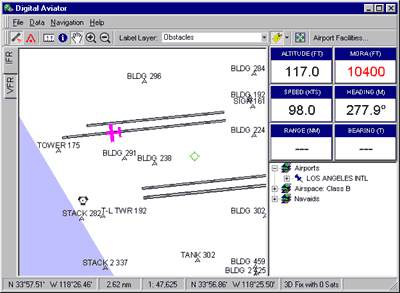
The US ObstaclePack is a collection of nearly 80,000 obstacles and
obstructions throughout North America. It depicts
all natural and man-made objects that pose a hazard to safe enflight navigation.
Like the IFR DataPack, the ObstaclePack is
tightly integrated with our free moving map application,
the Digital Aviator.

Details
The US ObstaclePack is derived from the Aviation Safety Database (ASDB),
part of the Position Integrity Geospatial Database Framework (GDF), an
enviornment for the collection and maintenance of global datasets that
aid in navigation. Although the ASDB contains more than 300,000 obstacles
and obstructions throughout the world, most of the international elements
are aviailable only to military organizations
and qualified defense contractors. Position Integrity is, however,
currently participating on several working groups within the defense
community to help promote the release of worldwide obstacle datasets.
OEM Licensing
Although the US ObstaclePack is specifically formatted to work in
conjunction with the Digital Aviator, the underlying data
are available for license by avionics manufacturers, software vendors,
and/or system integrators. Position Integrity offers flexible
tailored data services and can deliver
data in virtually
any format. We are already providing data to several key avionics
manufactures and software vendors.
For more information, please contact us by
telephone or email.


